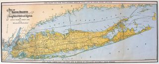
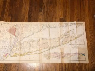
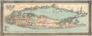
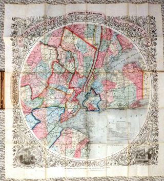
Colton’s Map Of Long Island And The Southern Part Of Connecticut


Item History & Price

Information:
Reference Number: Avaluer:44618834US State: Connecticut, New York
Date Range: 1800-1899Format: Folding Map
City: New YorkOriginal/Reproduction: Antique Original
Country/Region: United States of America
Original Description:
Colton’s Map of Long Island and the Southern Part of Connecticut. 1887 Attached to binding.  I’m located in Suffolk County on Long Island. 


    Similar items


  • Early 1950

    Early 1950 ' S Metsker ' S Map Of Southeast Washington And The Blue Mountain Area

  • 1911 Map Of Long Island Showing The Long Island Rr & Montauk Steamboat Systems

    1911 Map Of Long Island Showing The Long Island Rr & Montauk Steamboat Systems

  • 1843 Geology Of York In 4 Volumes; Mather Map Of Long Island And York

    1843 Geology Of York In 4 Volumes; Mather Map Of Long Island And York

  • Long Island 1866 Panoramic Traveller

    Long Island 1866 Panoramic Traveller ' S Map Of Long Island, York Art Prints

  • Vintage 30

    Vintage 30 ' S Map Of Long Island York Folk Art Embroidery Framed

  • Navigational Map - Oyster And Huntington Bays S.  Shore Of Long Island - Ny 224

    Navigational Map - Oyster And Huntington Bays S. Shore Of Long Island - Ny 224

  • Colton’s Map Of The Country Thirty Three Miles Around The City Of York 1864

    Colton’s Map Of The Country Thirty Three Miles Around The City Of York 1864

  • Antique 1861 Colton’s Map Of The State Of Texas

    Antique 1861 Colton’s Map Of The State Of Texas


    • You might also like


    • 1860 Mitchell Hand Colored Map Colorado,  Nebraska & Kansas - Civil War Era

      1860 Mitchell Hand Colored Map Colorado, Nebraska & Kansas - Civil War Era

    • 18th Century French Map Of North America

      18th Century French Map Of North America

    • Las Vegas Nevada Vintage 1967 Us Geological Survey Quadrangle Map 4 Panels

      Las Vegas Nevada Vintage 1967 Us Geological Survey Quadrangle Map 4 Panels

    • Rare Antique 1845 Maps United States Exploring Expedition Book Antartica Hawaii

      Rare Antique 1845 Maps United States Exploring Expedition Book Antartica Hawaii

    • Vintage 1926 Map Hollywood From The Best Surveys Of The Time

      Vintage 1926 Map Hollywood From The Best Surveys Of The Time

    • American Continent (western Hemisphere) 1747 Bowen Antique Copper Engraved Map

      American Continent (western Hemisphere) 1747 Bowen Antique Copper Engraved Map

    • Gulf Coast Florida Texas United States 1705 De Fer Unusual Antique Engraved Map

      Gulf Coast Florida Texas United States 1705 De Fer Unusual Antique Engraved Map

    • California As Island United States 1700 De Fer Unusual First Edition Antique Map

      California As Island United States 1700 De Fer Unusual First Edition Antique Map

Avaluer          About Us          Privacy Policy          Contact Us          UP
© 2022, avaluer.net, Inc. or its affiliates