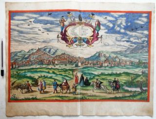
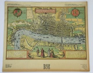
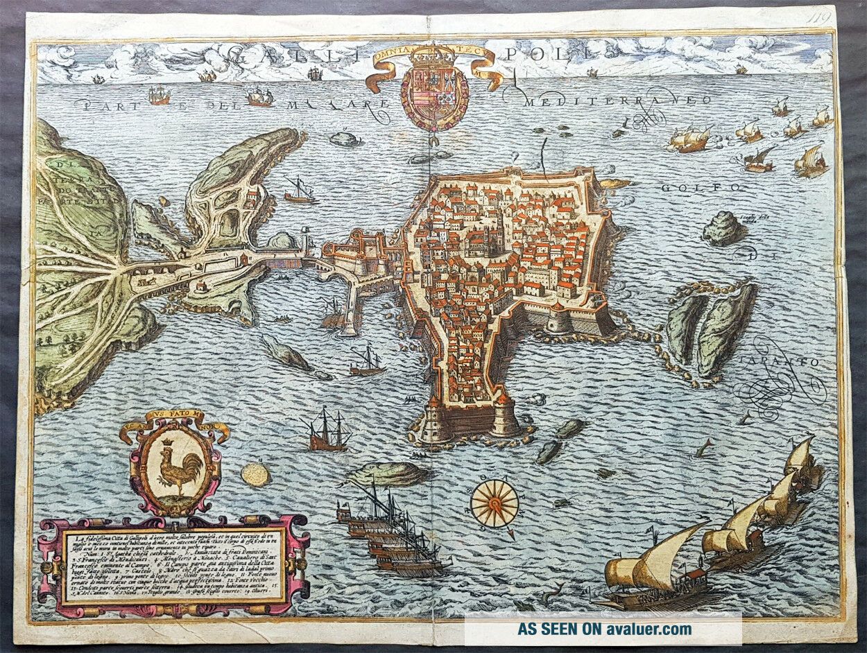
1598 Braun & Hogenberg Antique Map View Old Town Of Gallipoli Apulia South Italy
Item History & Price
| Reference Number: Avaluer:45880 |
contact usebay profileebay store Gallipolis Cartographer : - Braun and Hogenberg 1570 - 1619 Date: - 1598 Size: - 20 3/4in x 16in (520mm x 405mm)Ref#: - 82085Condition: - (A) Very Good ConditionDescription:
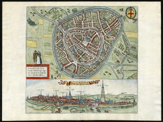
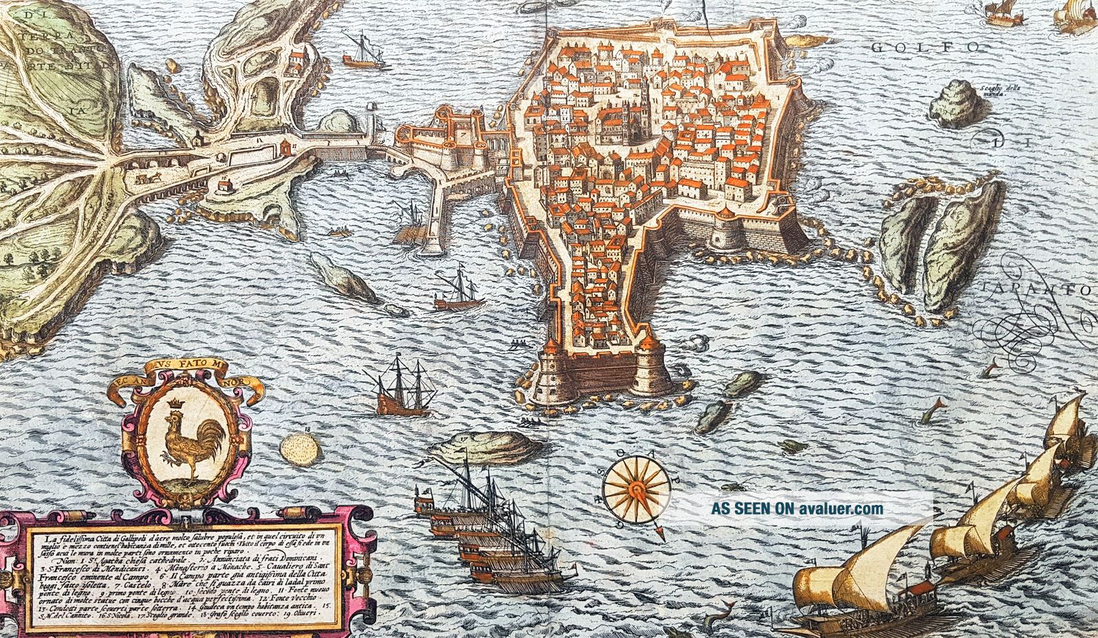
This beautiful original hand coloured copper plate engraved antique map a birds eye view of the Old Town of Gallipoli located on the Salentine Peninsula, in Apulia, Southern Italy & the Angevine-Aragonese Castle, was engraved by the Italian Natale Bonifacio di Girolamo, was published in t...he 1598 edition of Braun & Hogenbergs atlas on Civitates Orbis TerrarumGeneral Definitions:
Paper thickness and quality: - Heavy and stable
Paper color : - off white
Age of map color: - Original
Colors used: - Yellow, green, blue, pink
General color appearance: - Authentic
Paper size: - 20 3/4in x 16in (520mm x 405mm)
Plate size: - 20in x 16in (520mm x 405mm)
Margins: - Min 1/8in (3mm)Imperfections:
Margins: - Top of right margin cropped to border
Plate area: - None
Verso: - Light soilingBackground:
Gallipoli is a southern Italian town and comune in the province of Lecce, in Apulia.
The town is located by the Ionian Sea, on the west coast of the Salentina Peninsula. The town of Gallipoli is divided into two parts, the modern and the old city. The new town includes all the newest buildings including a skyscraper. The old town is located on a limestone island, linked to the mainland by a bridge built in the 16th century.
According to a legend, the city was founded in ancient times by Idomeneus of Crete. Pliny the Elder attributes the foundation to the Senones Gauls, while more likely it was a Messapic settlement. Historically, what is known is that Gallipoli was a city of the Greater Greece, ruling over a large territory including today\'s Porto Cesareo. In 265 BC it sided with Pyrrhus and Taranto against ancient Rome, suffering a defeat which relegated it to a Roman colony (later a municipium).
In the early Middle Ages, it was most likely sacked by the Vandals and the Goths. Rebuilt by the Byzantines, Gallipoli lived an economically and socially flourishing period due to its geographical position. Later it was owned by the Roman Popes, and was a centre of fighting against the Greek monastic orders.
In the 11th century Gallipoli was conquered by the Normans and, in 1268, it was besieged by Charles I of Anjou, causing numerous inhabitants to flee to the nearby Alezio. The city was repopulated around 1300, under the feudal rule of the principality of Taranto. In 1484 the Venetians tried to occupy it, but without results. King Ferdinand I of the Two Sicilies started the construction of the port, which in the 18th century became the largest olive oil market in the Mediterranean.
After the unification of Italy (1861), Gallipoli was capital of a circondario, together with Lecce and Taranto. Braun and Hogenberg 1570 - 1619
Georg Braun 1541 – 1622 was a topo-geographer. From 1572 to 1617 he edited the Civitates orbis terrarum, which contains 546 prospects, birds-eye views and maps of cities from all around the world. He was the principal editor of the work, he acquired the tables, hired the artists, and wrote the texts. He died as an octogenarian in 1622, as the only survivor of the original team to witness the publication of volume VI in 1617.
Frans Hogenberg 1535 – 1590 was a Flemish and German painter, engraver, and mapmaker. Hogenberg was born in Mechelen as the son of Nicolaas Hogenberg. In 1568 he was banned from Antwerp by the Duke of Alva and travelled to London, where he stayed a few years before emigrating to Cologne. He is known for portraits and topographical views as well as historical allegories. He also produced scenes of contemporary historical events.
In 1544 Sebastian Munster issued in Basle his Cosmographia containing about sixty plans and views, some in plan form, but many still using the old type of outline in elevation, and still others in birds-eye view. Very soon afterwards Frans Hogenberg, who engraved maps for Abraham Ortelius, together with another noted engraver of the time, Georg Hoefnagel, compiled and issued in Cologne a City Atlas intended as a companion work to the Theatrum Orbis Terrarum. Entitled Civitates Orbis Terrarum and edited by Georg Braun, the six volumes of this famous work were issued between the years 1572 and 1618 and contained in all more than 500 plans.
Civitates orbis terrarum This great city atlas, edited by Georg Braun and largely engraved by Franz Hogenberg, eventually contained 546 prospects, bird-eye views and map views of cities from all over the world. Braun (1541-1622), a cleric of Cologne, was the principal editor of the work, and was greatly assisted in his project by the close, and continued interest of Abraham Ortelius, whose Theatrum Orbis Terrarum of 1570 was, as a systematic and comprehensive collection of maps of uniform style, the first true atlas.
The Civitates, indeed, was intended as a companion for the Theatrum, as indicated by the similarity in the titles and by contemporary references regarding the complementary nature of two works. Nevertheless, the Civitates was designs to be more popular in approach, no doubt because the novelty of a collection of city plans and views represented a more hazardous commercial undertaking than a world atlas, for which there had been a number of successful precedents. Franz Hogenberg (1535-1590) was the son of a Munich engraves who settled in Malines. He engraved most of the plates for Ortelius\\\\\\\'s Theatrum and the majority of those in the Civitates, and may have been responsible for originating the project.
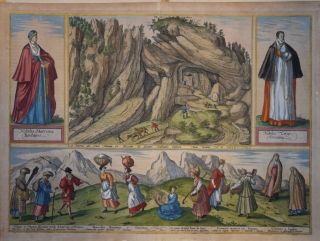
Over a hundred of different artists and cartographers, the most significant of whom was Antwerp artist Georg (Joris) Hoefnagel (1542-1600), engraved the cooper-plates of the Civitates from drawings. He not only contributed most of the original material for the Spanish and Italian towns but also reworked and modified those of other contributors. After Hoefnagel\\\\\\\'s death his son Jakob continued the work for the Civitates. A large number of Jacob van Deventer (1505-1575), also known as Jacob Roelofszof, unpublished works, plans of towns of the Netherlands were copied, as were Stumpf\\\\\\\'s woodcuts from the Schweizer Chronik of 1548, and Munster\\\\\\\'s German views from the 1550 and 1572 editions of his Cosmographia. Another important source for maps was the Danish cartographer Heinrich van Rantzau (1526-1599), beter known under his Latin name Rantzovius, who provided maps of Northern Europe, specially of Danish cities. The Civitates provided a uniquely comprehensive view of urban life at the turn of the sixteenth century. Other sources were the maps of Sebastian Munster from around 1550 and , and of Braun added to the maps figures in local dress. This feature was anticipated in Hans Lautensack\\\\\\\'s etched view of Nuremberg, 1552, those groups of citizens in the rural foreground add further authenticity to the highly accurate topographical details of what was effectively Germany\\\\\\\'s cultural capital at that time. Braun\\\\\\\'s motives for adding figures to the views, however, went further: as stated in his introduction to book 1, he believed, perhaps optimistically, that his plans would not in consequence be scrutinized for military secrets by the Turks, as their religion forbade them from looking on representations of the human form.
The plans, each accompanies by Braun\\\\\\\'s printed account of the town\\\\\\\'s history, situation and commerce, form an armchair traveler\\\\\\\'s compendium, which the scholar Robert Burton in The Anatomy of Melancholy of 1621 asserted would not only provide instructions but would uplift the spirit as well.
- 1572 Civitates Orbis Terrarum Vol. 1
- 1575 Civitates Orbis Terrarum Vol.11
- 1581 Civitates Orbis Terrarum Vol.111
- 1588 Civitates Orbis Terrarum Vol. IV
- 1598 Civitates Orbis Terrarum Vol. V
- 1618 Civitates Orbis Terrarum Vol. VI
These volumes were published originally with Latin text followed by re-issues with German and French translations. Volume V1 comprised an issue of Supplementary plans. Sometime after 1618 the plates passed into possession of Abraham Hogenberg who was responsible for a number of further re-issues and after his death the plates were acquired by Jan Jansson. Using them as a basis Jansson published an 8-volume edition and this in turn was followed by further reissues.
Please note all items auctioned are genuine, we do not sell reproductions. A Certificate of Authenticity (COA) can be issued on request.
What is an Antique MapThe word Antique in the traditional sense refers to an item that is more than a hundred years old. In the past maps were sold in two forms, as a single sheet (broadsheet) or bound in an atlas or book. The majority of antique maps for sale today come from books or atlases and have survived due to the protection offered by the hardback covers.
When considering a purchase The first thing to determine when staring a collection or purchasing an item, is what is important to you. Most collectors prefer to build their collections around a theme. You may decide to collect maps from one region or country, charting its development through time. Similarly you could collect maps of one particular period in time, by type (i.e. sea or celestial charts) or by cartographer. The collector might also want to consider the theme of cartographical misconceptions such as California as an island or Australia as Terra Australis or the Great Southern Land.
The subject is so wide that any would-be-collector has almost endless possibilities to find his own little niche within the field, and thereby build a rewarding collection.
Starting a collection & pricingPricing is based on a number of different factors, the most important of which is regional. In any series of maps the most valuable are usually the World Map and the America/North America. The World because it is usually the most decorative and America because it has the strongest regional market. Other factors that come into play re: price is rarity, age, size, historical importance, decorative value (colour) and overall condition and quality of paper it is printed on.
As specialised dealers, we frequently work with first time map buyers who are just starting their collection. Guiding new collectors on their first antique map purchase and helping new collectors to focus their interests is one of the most rewarding aspects of being an rare map dealer. So please do not hesitate to contact us and we will be happy to help with any questions you may have.
Payment, Shipping & Return OptionsPlease click on the \"Shipping and Payments\" Tab above for shipping, payment and return details
About USClassical Images was founded 1998 and has built an excellent reputation for supplying high quality original antiquarian maps, historical atlases, antique books and prints. We carry an extensive inventory of antiquarian collectibles from the 15th to 19th century. Our collection typically includes rare books and decorative antique maps and prints by renowned cartographers, authors and engravers. Specific items not listed may be sourced on request.
Classical Images adheres to the Codes of Ethics outlined by the Antiquarian Booksellers Association of America (ABAA).
We are a primarily an online based enterprise, however our inventory may be viewed by appointment. Please call or email to arrange a viewing.
This beautiful original hand coloured copper plate engraved antique map a birds eye view of the Old Town of Gallipoli located on the Salentine Peninsula, in Apulia, Southern Italy & the Angevine-Aragonese Castle, was engraved by the Italian Natale Bonifacio di Girolamo, was published in t...he 1598 edition of Braun & Hogenbergs atlas on Civitates Orbis TerrarumGeneral Definitions:
Paper thickness and quality: - Heavy and stable
Paper color : - off white
Age of map color: - Original
Colors used: - Yellow, green, blue, pink
General color appearance: - Authentic
Paper size: - 20 3/4in x 16in (520mm x 405mm)
Plate size: - 20in x 16in (520mm x 405mm)
Margins: - Min 1/8in (3mm)Imperfections:
Margins: - Top of right margin cropped to border
Plate area: - None
Verso: - Light soilingBackground:
Gallipoli is a southern Italian town and comune in the province of Lecce, in Apulia.
The town is located by the Ionian Sea, on the west coast of the Salentina Peninsula. The town of Gallipoli is divided into two parts, the modern and the old city. The new town includes all the newest buildings including a skyscraper. The old town is located on a limestone island, linked to the mainland by a bridge built in the 16th century.
According to a legend, the city was founded in ancient times by Idomeneus of Crete. Pliny the Elder attributes the foundation to the Senones Gauls, while more likely it was a Messapic settlement. Historically, what is known is that Gallipoli was a city of the Greater Greece, ruling over a large territory including today\'s Porto Cesareo. In 265 BC it sided with Pyrrhus and Taranto against ancient Rome, suffering a defeat which relegated it to a Roman colony (later a municipium).
In the early Middle Ages, it was most likely sacked by the Vandals and the Goths. Rebuilt by the Byzantines, Gallipoli lived an economically and socially flourishing period due to its geographical position. Later it was owned by the Roman Popes, and was a centre of fighting against the Greek monastic orders.
In the 11th century Gallipoli was conquered by the Normans and, in 1268, it was besieged by Charles I of Anjou, causing numerous inhabitants to flee to the nearby Alezio. The city was repopulated around 1300, under the feudal rule of the principality of Taranto. In 1484 the Venetians tried to occupy it, but without results. King Ferdinand I of the Two Sicilies started the construction of the port, which in the 18th century became the largest olive oil market in the Mediterranean.
After the unification of Italy (1861), Gallipoli was capital of a circondario, together with Lecce and Taranto. Braun and Hogenberg 1570 - 1619
Georg Braun 1541 – 1622 was a topo-geographer. From 1572 to 1617 he edited the Civitates orbis terrarum, which contains 546 prospects, birds-eye views and maps of cities from all around the world. He was the principal editor of the work, he acquired the tables, hired the artists, and wrote the texts. He died as an octogenarian in 1622, as the only survivor of the original team to witness the publication of volume VI in 1617.
Frans Hogenberg 1535 – 1590 was a Flemish and German painter, engraver, and mapmaker. Hogenberg was born in Mechelen as the son of Nicolaas Hogenberg. In 1568 he was banned from Antwerp by the Duke of Alva and travelled to London, where he stayed a few years before emigrating to Cologne. He is known for portraits and topographical views as well as historical allegories. He also produced scenes of contemporary historical events.
In 1544 Sebastian Munster issued in Basle his Cosmographia containing about sixty plans and views, some in plan form, but many still using the old type of outline in elevation, and still others in birds-eye view. Very soon afterwards Frans Hogenberg, who engraved maps for Abraham Ortelius, together with another noted engraver of the time, Georg Hoefnagel, compiled and issued in Cologne a City Atlas intended as a companion work to the Theatrum Orbis Terrarum. Entitled Civitates Orbis Terrarum and edited by Georg Braun, the six volumes of this famous work were issued between the years 1572 and 1618 and contained in all more than 500 plans.
Civitates orbis terrarum This great city atlas, edited by Georg Braun and largely engraved by Franz Hogenberg, eventually contained 546 prospects, bird-eye views and map views of cities from all over the world. Braun (1541-1622), a cleric of Cologne, was the principal editor of the work, and was greatly assisted in his project by the close, and continued interest of Abraham Ortelius, whose Theatrum Orbis Terrarum of 1570 was, as a systematic and comprehensive collection of maps of uniform style, the first true atlas.
The Civitates, indeed, was intended as a companion for the Theatrum, as indicated by the similarity in the titles and by contemporary references regarding the complementary nature of two works. Nevertheless, the Civitates was designs to be more popular in approach, no doubt because the novelty of a collection of city plans and views represented a more hazardous commercial undertaking than a world atlas, for which there had been a number of successful precedents. Franz Hogenberg (1535-1590) was the son of a Munich engraves who settled in Malines. He engraved most of the plates for Ortelius\\\\\\\'s Theatrum and the majority of those in the Civitates, and may have been responsible for originating the project.
Over a hundred of different artists and cartographers, the most significant of whom was Antwerp artist Georg (Joris) Hoefnagel (1542-1600), engraved the cooper-plates of the Civitates from drawings. He not only contributed most of the original material for the Spanish and Italian towns but also reworked and modified those of other contributors. After Hoefnagel\\\\\\\'s death his son Jakob continued the work for the Civitates. A large number of Jacob van Deventer (1505-1575), also known as Jacob Roelofszof, unpublished works, plans of towns of the Netherlands were copied, as were Stumpf\\\\\\\'s woodcuts from the Schweizer Chronik of 1548, and Munster\\\\\\\'s German views from the 1550 and 1572 editions of his Cosmographia. Another important source for maps was the Danish cartographer Heinrich van Rantzau (1526-1599), beter known under his Latin name Rantzovius, who provided maps of Northern Europe, specially of Danish cities. The Civitates provided a uniquely comprehensive view of urban life at the turn of the sixteenth century. Other sources were the maps of Sebastian Munster from around 1550 and , and of Braun added to the maps figures in local dress. This feature was anticipated in Hans Lautensack\\\\\\\'s etched view of Nuremberg, 1552, those groups of citizens in the rural foreground add further authenticity to the highly accurate topographical details of what was effectively Germany\\\\\\\'s cultural capital at that time. Braun\\\\\\\'s motives for adding figures to the views, however, went further: as stated in his introduction to book 1, he believed, perhaps optimistically, that his plans would not in consequence be scrutinized for military secrets by the Turks, as their religion forbade them from looking on representations of the human form.
The plans, each accompanies by Braun\\\\\\\'s printed account of the town\\\\\\\'s history, situation and commerce, form an armchair traveler\\\\\\\'s compendium, which the scholar Robert Burton in The Anatomy of Melancholy of 1621 asserted would not only provide instructions but would uplift the spirit as well.
- 1572 Civitates Orbis Terrarum Vol. 1
- 1575 Civitates Orbis Terrarum Vol.11
- 1581 Civitates Orbis Terrarum Vol.111
- 1588 Civitates Orbis Terrarum Vol. IV
- 1598 Civitates Orbis Terrarum Vol. V
- 1618 Civitates Orbis Terrarum Vol. VI
These volumes were published originally with Latin text followed by re-issues with German and French translations. Volume V1 comprised an issue of Supplementary plans. Sometime after 1618 the plates passed into possession of Abraham Hogenberg who was responsible for a number of further re-issues and after his death the plates were acquired by Jan Jansson. Using them as a basis Jansson published an 8-volume edition and this in turn was followed by further reissues.
Please note all items auctioned are genuine, we do not sell reproductions. A Certificate of Authenticity (COA) can be issued on request.
What is an Antique MapThe word Antique in the traditional sense refers to an item that is more than a hundred years old. In the past maps were sold in two forms, as a single sheet (broadsheet) or bound in an atlas or book. The majority of antique maps for sale today come from books or atlases and have survived due to the protection offered by the hardback covers.
When considering a purchase The first thing to determine when staring a collection or purchasing an item, is what is important to you. Most collectors prefer to build their collections around a theme. You may decide to collect maps from one region or country, charting its development through time. Similarly you could collect maps of one particular period in time, by type (i.e. sea or celestial charts) or by cartographer. The collector might also want to consider the theme of cartographical misconceptions such as California as an island or Australia as Terra Australis or the Great Southern Land.
The subject is so wide that any would-be-collector has almost endless possibilities to find his own little niche within the field, and thereby build a rewarding collection.
Starting a collection & pricingPricing is based on a number of different factors, the most important of which is regional. In any series of maps the most valuable are usually the World Map and the America/North America. The World because it is usually the most decorative and America because it has the strongest regional market. Other factors that come into play re: price is rarity, age, size, historical importance, decorative value (colour) and overall condition and quality of paper it is printed on.
As specialised dealers, we frequently work with first time map buyers who are just starting their collection. Guiding new collectors on their first antique map purchase and helping new collectors to focus their interests is one of the most rewarding aspects of being an rare map dealer. So please do not hesitate to contact us and we will be happy to help with any questions you may have.
Payment, Shipping & Return OptionsPlease click on the \"Shipping and Payments\" Tab above for shipping, payment and return details
About USClassical Images was founded 1998 and has built an excellent reputation for supplying high quality original antiquarian maps, historical atlases, antique books and prints. We carry an extensive inventory of antiquarian collectibles from the 15th to 19th century. Our collection typically includes rare books and decorative antique maps and prints by renowned cartographers, authors and engravers. Specific items not listed may be sourced on request.
Classical Images adheres to the Codes of Ethics outlined by the Antiquarian Booksellers Association of America (ABAA).
We are a primarily an online based enterprise, however our inventory may be viewed by appointment. Please call or email to arrange a viewing.