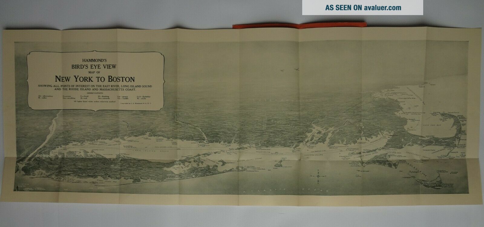
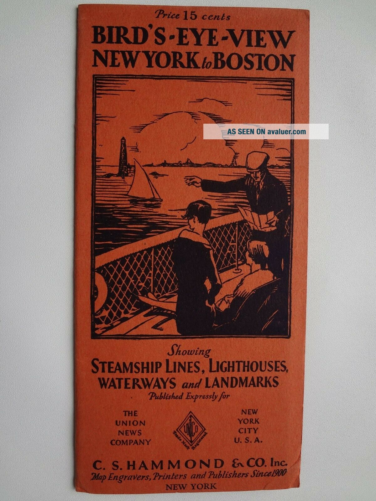
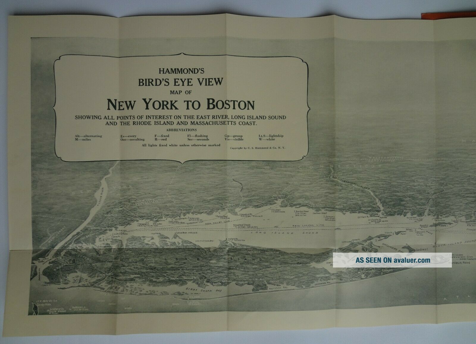
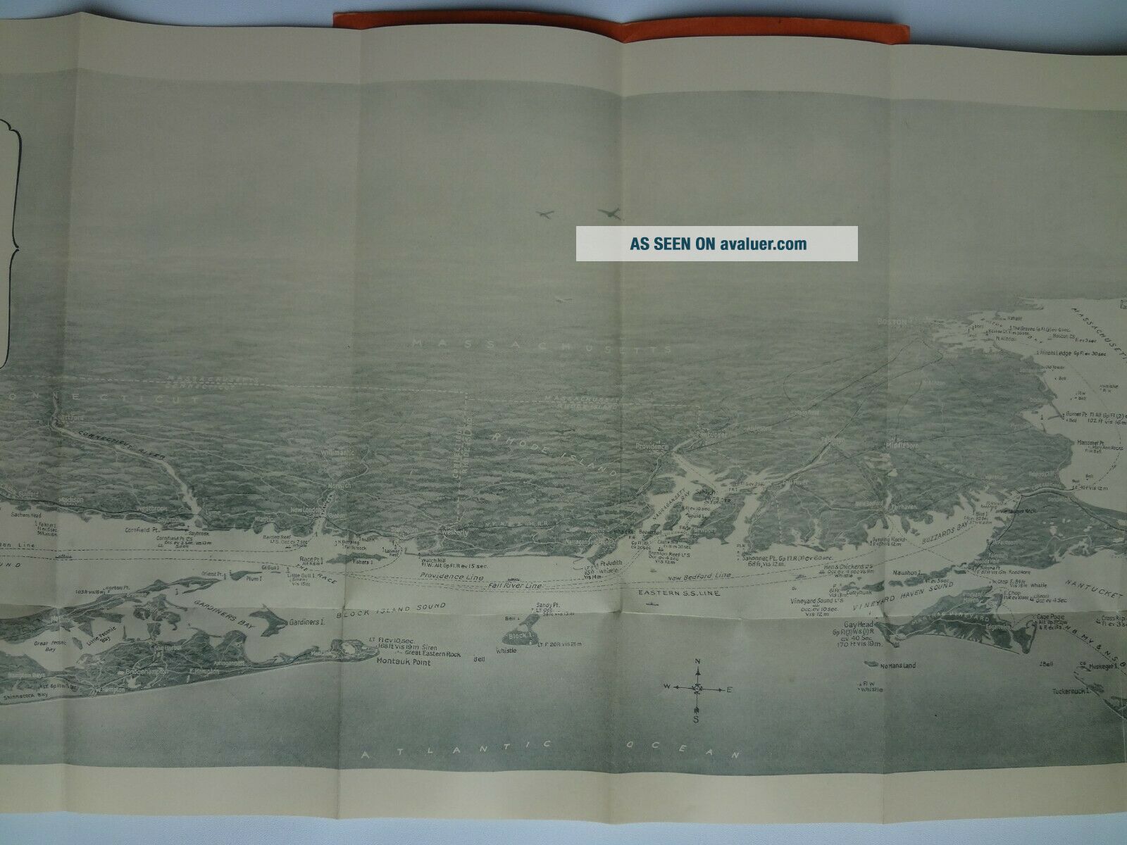
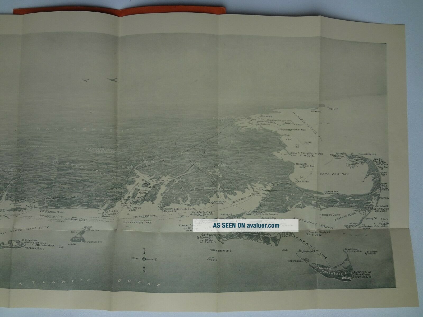
Map - BIRD ' S - EYE - VIEW YORK To BOSTON, Showing Steamship Lines. Circa 1930


Item History & Price

Information:
Reference Number: Avaluer:45999Type: Pictorial/Bird's Eye
City: New YorkDate Range: 1930-1939
Country/Region: United States of AmericaUS State: Massachusetts, New York
Original Description:
BIRD'S-EYE-VIEW NEW YORK to BOSTON, Showing Steamship Lines, Lighthouses, Waterways and Landmarks. Published Expressly for The Union News Company, New York City, U.S.A. - C.S. Hammond & Co. Inc. Map Engravers, Printers and Publishers Since 1900.
Circa 1930 - 10 5/8 x 29 1/2 inches
Map is in excellent condition, folded as issued in original cover. See images for details and feel free to contact seller for specific questions or detail images.


...


    Similar items


  • Lodi Ca Town Map Bird

    Lodi Ca Town Map Bird ' S Eye View Lithograph San Joaquin County Vintage 1960 ' S

  • Paris Map,  Bird

    Paris Map, Bird ' S - Eye View Of Paris From Heights Of Sceaux, 1870 Map

  • Milford Connecticut Map Bird

    Milford Connecticut Map Bird ' S Eye View Images 1855 By E. R. Lambert 30x24 Print

  • 1894 Map Bird

    1894 Map Bird ' S - Eye - View Holy Land Jerusalem Damascus Beirut Bethlehem

  • John Bachmann France Paris Place De La Concorde Before 1847 Map Bird

    John Bachmann France Paris Place De La Concorde Before 1847 Map Bird ' S Eye View

  • Massapequa Park Long Island Ny Development Map Bird

    Massapequa Park Long Island Ny Development Map Bird ' S Eye View 1930s Jones Beach

  • Lake Tahoe California/nevada Pictorial Map,  Bird

    Lake Tahoe California/nevada Pictorial Map, Bird ' S Eye Vies, Panoramic

  • Ca 1930 San Francisco Map Bird

    Ca 1930 San Francisco Map Bird ' S Eye View Convention & Tourist League California


    • You might also like


    • 1860 Mitchell Hand Colored Map Colorado,  Nebraska & Kansas - Civil War Era

      1860 Mitchell Hand Colored Map Colorado, Nebraska & Kansas - Civil War Era

    • 18th Century French Map Of North America

      18th Century French Map Of North America

    • Las Vegas Nevada Vintage 1967 Us Geological Survey Quadrangle Map 4 Panels

      Las Vegas Nevada Vintage 1967 Us Geological Survey Quadrangle Map 4 Panels

    • Rare Antique 1845 Maps United States Exploring Expedition Book Antartica Hawaii

      Rare Antique 1845 Maps United States Exploring Expedition Book Antartica Hawaii

    • Vintage 1926 Map Hollywood From The Best Surveys Of The Time

      Vintage 1926 Map Hollywood From The Best Surveys Of The Time

    • American Continent (western Hemisphere) 1747 Bowen Antique Copper Engraved Map

      American Continent (western Hemisphere) 1747 Bowen Antique Copper Engraved Map

    • Gulf Coast Florida Texas United States 1705 De Fer Unusual Antique Engraved Map

      Gulf Coast Florida Texas United States 1705 De Fer Unusual Antique Engraved Map

    • California As Island United States 1700 De Fer Unusual First Edition Antique Map

      California As Island United States 1700 De Fer Unusual First Edition Antique Map

Avaluer          About Us          Privacy Policy          Contact Us          UP
© 2022, avaluer.net, Inc. or its affiliates