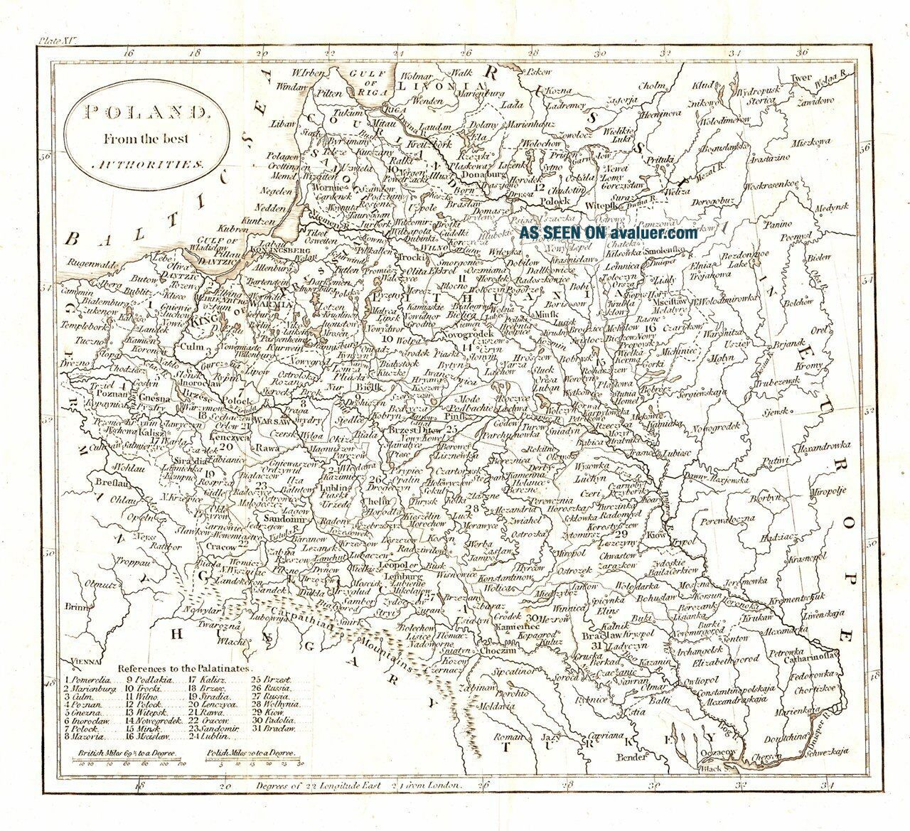
Antique Map, Poland From The Best Authorities


Item History & Price

Information:
Reference Number: Avaluer:48240767
Original Description:
Description:FULL TITLE: Poland from the best authoritiesA highly detailed engraving of the Commonwealth of Poland & Lithuania showing a large portion of the Ukraine now belonging to Russia. Folds as given. Conditon: GGCartographer: Russell. JDate: 1787Technique: Copper EngravingColour: UncolouredWidth (cms) x Height (cms): 20.7 x 18.5Ref: JJB1062
Powered by eBay Turbo Lister


    Similar items


  • 1807 Antique H/col Map - Germany From The Best Authorities

    1807 Antique H/col Map - Germany From The Best Authorities

  • 1806 Antique Map; Africa From The Latest Authorities - James Barlow

    1806 Antique Map; Africa From The Latest Authorities - James Barlow

  • C1800 The Modern Royal Atlas From The Best Authorities - Coloured Antique Maps

    C1800 The Modern Royal Atlas From The Best Authorities - Coloured Antique Maps

  • 1807 Antique H/col Map - The Seven United Provinces From The Best Authorities

    1807 Antique H/col Map - The Seven United Provinces From The Best Authorities

  • 1795 A Correct Map Of Ireland From The Best Authorities

    1795 A Correct Map Of Ireland From The Best Authorities

  • 1700s A Map Of Gloucestershire Drawn From The Best Authorities

    1700s A Map Of Gloucestershire Drawn From The Best Authorities

  • C1792 Map Of West Indies From The Best Authorities,  J.  Russell Outline Color

    C1792 Map Of West Indies From The Best Authorities, J. Russell Outline Color

  • C1790s,  Map Of Northumberland From The Best Authorities,  John Lodge

    C1790s, Map Of Northumberland From The Best Authorities, John Lodge


    • You might also like


    • Hungary & Romania 1579 (1584) Ortelius Unusual Antique Copper Engraved Map

      Hungary & Romania 1579 (1584) Ortelius Unusual Antique Copper Engraved Map

    • Brussels Bruxelles Belfium 1777 De Ferraris & Dupuis Large Antique Map Sheet Xxi

      Brussels Bruxelles Belfium 1777 De Ferraris & Dupuis Large Antique Map Sheet Xxi

    • 1616 Atlas Map Of Iceland.

      1616 Atlas Map Of Iceland.

    • Kazan Russia 1767 Le Clerc/lespinasse Antique Copper Engraved City View

      Kazan Russia 1767 Le Clerc/lespinasse Antique Copper Engraved City View

    • 1899 Stanford,  Folding Map Of Norwich,  Norfolk,  Arthur Collins,  Jarrold & Sons,

      1899 Stanford, Folding Map Of Norwich, Norfolk, Arthur Collins, Jarrold & Sons,

    • 1948 Vintage Linen Colour Map Geological Survey Ten Mile Of Great Britain

      1948 Vintage Linen Colour Map Geological Survey Ten Mile Of Great Britain

    • 1944 Map Flying Bombs Sussex Ww2 Newspaper Military Kent Courier German V1 V2

      1944 Map Flying Bombs Sussex Ww2 Newspaper Military Kent Courier German V1 V2

    • Dated 1638 Vellum Map Of Icklesham Sussex Showing Land Uses Owners Etc

      Dated 1638 Vellum Map Of Icklesham Sussex Showing Land Uses Owners Etc

Avaluer          About Us          Privacy Policy          Contact Us          UP
© 2022, avaluer.net, Inc. or its affiliates