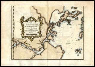
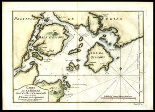
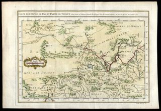
1752 Copper Engraved Hand Colored Detailed Map West African Slave Coast


Item History & Price
Click on the image
for a detailed view. Maker: Jean Baptiste Bourguignon d' Anville and Engraver: G. ChildDate: 1752, LondonShort Title: A Map of the Kingdoms of Koto, Popo, Fida ot Whidah and ArdraFull Title: A Map of the Kingdoms of Koto, Popo, Fida ot Whidah and Ardra. Being a continuation of the former by M.D. Anville 1727 Source: A New Gereral Collection of Voyages and Travels consisting of the most Esteemed Relations, which have been hitherto published in any Languag...e..." Plate 184, No. 105 vol 2 p. 304 Published by T. Astley Plate 184, No.105, Vol. 2, p. 394.Size of Map: 14.5 x 23 cm. approximately (58.71 x 9.06 in.)Description: A copper engraved, hand colored detailed map, of a stretch of the West Africa slave coast with an insert of the French Fort at Whidah. References: New York Public Library Record ID: 351923; Tooley’s Dictionary of Mapmakers (Revised Edition) Vol. (A-D) p264.A Great Gift For Any Manuscript Collector We Now Accept PayPal! We Ship Worldwide. Please Contact Us For a Free Shipping Quote!