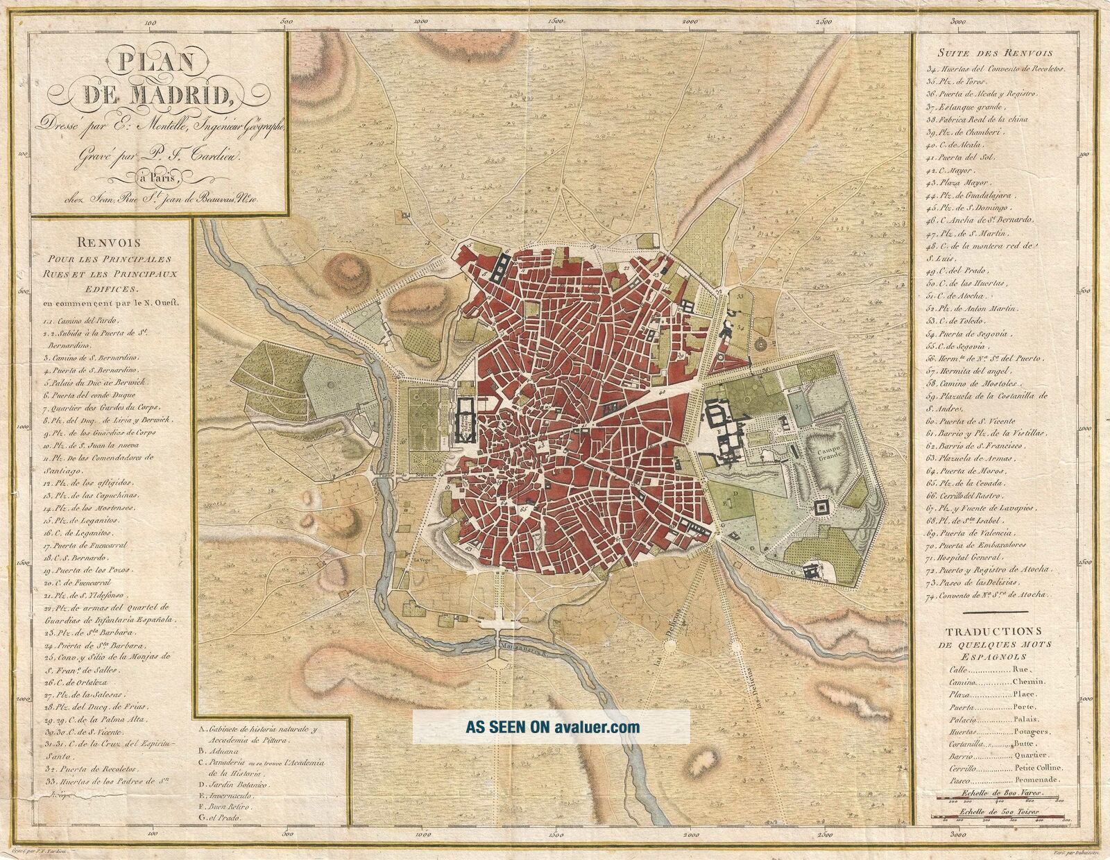
1782 Mentelle Map Or Plan Of Madrid, Spain
Item History & Price
| Reference Number: Avaluer:30033 |
1782 Mentelle Map or Plan of Madrid, Spain
WE SELL ONLY ORIGINAL ANTIQUE MAPS - NOT REPRODUCTIONS
Title: Plan de Madrid.
Description: This is a 1782 Edme Mentelle map or plan of Madrid, Spain. This map depicts the city of Madrid from the Manzanares River in the west to the Campo Grande in the east and from the Puerta de Embaxadores in the south to the Puerta des los Pozos in the north as well as a significant amount of countryside surrounding the city. The ...map is highly detailed but very clean. Instead of labeling streets and buildings on the map itself, a list of 74 of the 'principle streets and buildings' in Madrid. The Plaza Grand de Palacio Real is labeled on the map as well as the Campo Grande. In the countryside around the city, trees are depicted in profile and several hills are included to show the topography of the region.
This map was prepared by Edme Mentelle, drawn by Dubuisson, and engraved by Pierre-François Tardieu. The map was published in Paris by chez Jean as a part of Edme Mentelle's Atlas nouveau.
Size: Printed area measures 13.5 inches high by 17 inches wide.
Condition: Very good. A few minor repaired tears on verso along margins. One repaired tear extending 2 inches into printed area at lower left corner. Light foxing. Blank on verso.
Shipping: Shipping rates are not negotiable. Items are shipped within three business days of receiving payment. We are happy to consolidate shipping where possible. The following shipping options are available: 1. FedEx Overnight (45 USD). USA Only. Signature Required.
2. FedEx Ground or Home Delivery (15 USD). USA Only. 1 - 10 days. If your address is a P.O. Box and cannot ship FedEx we will ship USPS Priority and, while we ship promptly, recent postal personnel cutbacks mean that delivery may take time. Signature Required.
3. FedEx International or DHL International EXPRESS (45 USD).
4. We can use your FedEx Account.
Customs: International buyers are responsible for paying duty and taxes on delivery. DHL or FedEx will contact the buyer by telephone to arrange tax payment if it is levied. Duty varies by country and we cannot predict the amount you will be charged. Some countries are duty free, others are not. Typically, a customs duty and/or VAT tax will be assessed on all parcels to continental Europe. Sometimes duty or tax is due in China, but is seems very random. Hong Kong, Singapore, Korea, and Taiwan have never assessed duty on a map we shipped. Maps shipped to the UK should be duty free as educational materials, but from time to time duty of 5% is assessed incorrectly by the UK customs agents.
Insurance: All shipments are insured privately against loss and damage. All of our shipments require a signature for insurance purposes.
If you have any questions please feel free to email us through eBay.
Other ServicesConservation Framing: Geographicus recommends basic conservation framing services for any antique paper. We do not offer this service.
Antique Map Restoration: Geographicus can repair and restore your antique map. Services include deacidification cleaning flattening and backing.
BEWARE anyone attempting to contact you, from a different eBay account, claiming to represent Geographicus Antique Maps. My eBay handle is GeographicusMaps. If you are contacted by email by someone offering you my items, please call me directly to be certain you are not dealing with a con artist. "