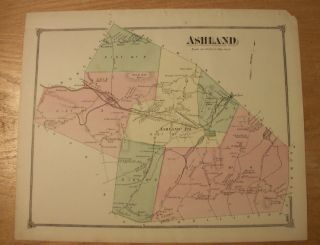
Rare 1875 Map Of Lyndon, Vermont From Atlas Of Caledonia County W/family Names


Item History & Price
| Reference Number: Avaluer:48258894 | Cartographer/Publisher: F W Beers |
| US State: Vermont | Original/Reproduction: Original |
| Maker: F W Beers | Type: Map |
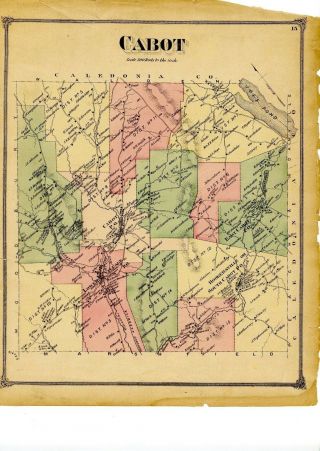
Here is an interesting antique map of Lyndon, Vermont, in Caledonia County, from the Atlas of Caledonia County, Vermont, published in 1875 by F. W. Beers. Handcolored in green, pink and yellow. Approximately 12.75 by 16 inches in size. This is an original map from the 1875 atlas, not a reproduction.
Condition: Binding holes in left margin. See all scans. This map is larger than my scanner ... see all scans to see all margins.
Like most Beers' maps, every house on this map i...s identified by the property owner's name. Among the surnames shown: Eastman, Willey, Mathewson, Bundy, Ingerson, Sitsb, quimby, Bermis, Gilson, Gage, Burington, Eggleston, Hoyt, Folsom, Sanborn, Gilbert, Spencer, Locklin, Houghton, Kilby, Simpson, Fawson, Graves, Howard, Hubbard, Randall, Darling, Bickford, Carpenter, etc.
Also shown: Large sugar grove, Conn & Pss Rivers Railroad, Saw Mill, Iron Ore, Schoolhouses, Lumber Yard, Town Farm, Meadow Farm, Shelton Brook, Chair Factory, Great Falls, Saw & Grist Mill, Marble Shop, Freight Depot, Barn Built 1792, etc.
This original 1875 map of Lyndon, Vermont, would make a great gift for someone interested in the history or genealogy of Lyndon, or especially for a member of one of the families mentioned on the map.
There are some mentions of genealogical and historical interest on this map. For example: David Eastman Settled in 1806; Job Randall settled here 1801; D. Cahoon Settled here in1788, as the First Settle in Town, etc.
The title page of the Caledonia County Atlas is shown here to show the source of this map. The title page is NOT included in this sale.
We ship maps flat, in a clear plastic envelope, with a 200 lb test corrugated backer, in a 200 lb test folder, by Priority Mail ... to get to you safely.