1867 US Coast Survey Map Savannah River & Wassaw Sound Georgia


Item History & Price

Information:
Reference Number: Avaluer:59363927Cartographer/Publisher: A.D. Bache
Year: 1867Printing Technique: Lithography
US State: GeorgiaOriginal/Reproduction: Antique Original
City: SavannahFormat: Folding Map
Date Range: 1800-1899Type: River Map
Country/Region: United States of America
Original Description:
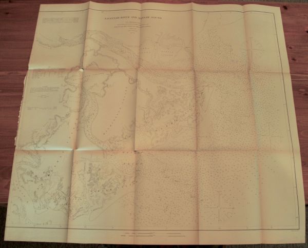
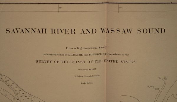
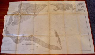
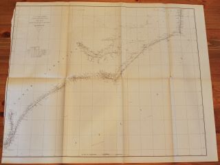
US Coast Survey Savannah River and Wassaw Sound, GeorgiaFrom a Trigonometrical Survey under the direction of A.D. Bache and B. Peirce Superintendents
Map No. 16B. Peirce SuperintendentPublished in 1867
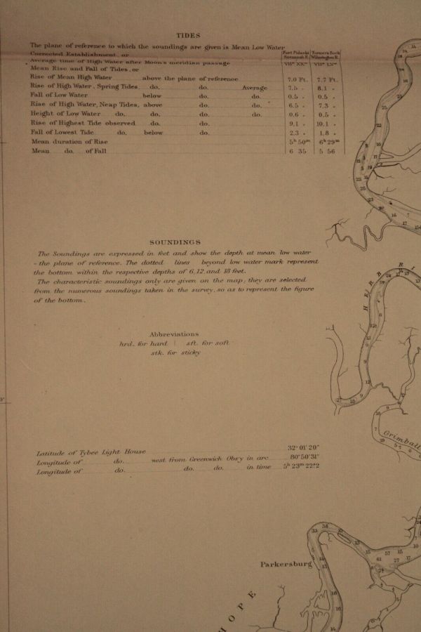
Includes Tides and SoundingsFragile condition with discoloration along folds and 7 holes at fold intersections35" x 33"
Item #MCS-80
Shipping is standard post (no tracking) for Canada and US. Express, tracking, and international shipping by quote. If purchasing multiple items... within 3 days, we will send an invoice with a combined shipping discount.
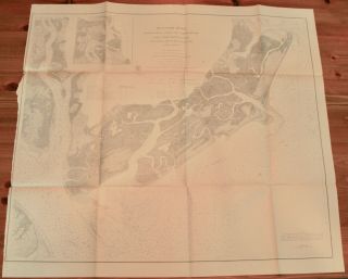


    Similar items


  • 1852 South Carolina Coast Survey Map Savannah River - Bull

    1852 South Carolina Coast Survey Map Savannah River - Bull ' S Bay Hilton Hea

  • 1867 Us Coast Survey Map Of Puget Sound,  Washington Territory

    1867 Us Coast Survey Map Of Puget Sound, Washington Territory

  • 1867 Us Coast Survey Map York Entrance Incl Staten Island

    1867 Us Coast Survey Map York Entrance Incl Staten Island

  • 1873 Us Coast Survey Map Beaufort River,  South Carolina

    1873 Us Coast Survey Map Beaufort River, South Carolina

  • 1867 Us Coast Survey Map Of Shilshole Bay,  Puget Sound,  Washington Territory

    1867 Us Coast Survey Map Of Shilshole Bay, Puget Sound, Washington Territory

  • 1867 Us Coast Survey Map Pamlico Sound,  Outer Banks,  North Carolina

    1867 Us Coast Survey Map Pamlico Sound, Outer Banks, North Carolina

  • 1862 Us Coast Survey Map Hudson River Poughkeepsie To Glasco York

    1862 Us Coast Survey Map Hudson River Poughkeepsie To Glasco York

  • 1867 Us Coast Survey Map Port Of Berne [bern],  North Carolina

    1867 Us Coast Survey Map Port Of Berne [bern], North Carolina


    • You might also like


    • 1860 Mitchell Hand Colored Map Colorado,  Nebraska & Kansas - Civil War Era

      1860 Mitchell Hand Colored Map Colorado, Nebraska & Kansas - Civil War Era

    • 18th Century French Map Of North America

      18th Century French Map Of North America

    • Las Vegas Nevada Vintage 1967 Us Geological Survey Quadrangle Map 4 Panels

      Las Vegas Nevada Vintage 1967 Us Geological Survey Quadrangle Map 4 Panels

    • Rare Antique 1845 Maps United States Exploring Expedition Book Antartica Hawaii

      Rare Antique 1845 Maps United States Exploring Expedition Book Antartica Hawaii

    • Vintage 1926 Map Hollywood From The Best Surveys Of The Time

      Vintage 1926 Map Hollywood From The Best Surveys Of The Time

    • American Continent (western Hemisphere) 1747 Bowen Antique Copper Engraved Map

      American Continent (western Hemisphere) 1747 Bowen Antique Copper Engraved Map

    • Gulf Coast Florida Texas United States 1705 De Fer Unusual Antique Engraved Map

      Gulf Coast Florida Texas United States 1705 De Fer Unusual Antique Engraved Map

    • California As Island United States 1700 De Fer Unusual First Edition Antique Map

      California As Island United States 1700 De Fer Unusual First Edition Antique Map

Avaluer          About Us          Privacy Policy          Contact Us          UP
© 2022, avaluer.net, Inc. or its affiliates